Great Bear Drills 29.17 g/t Gold Over 15.50 m and 18.08 g/t Gold Over 15.80 m From Bedrock Surface at LP Fault
March 11, 2021 – Vancouver, British Columbia, Canada – Great Bear Resources Ltd. (the "Company" or "Great Bear", TSX-V: GBR; OTCQX: GTBAF) today reported results from its ongoing fully funded $45 million 2021 exploration program at its 100% owned flagship Dixie Project in the Red Lake district of Ontario.
Chris Taylor, President and CEO of Great Bear said, “We believe the LP Fault represents one of the largest consistently mineralized new gold discoveries being explored today. We encourage investors to review and compare the LP Fault cross sections provided in this release to those provided on February 8, 2021.”
This news release provides results from 10 new LP Fault drill holes completed along 225 metres of strike length. Great Bear has now published results from 260 LP Fault drill holes and anticipates at least 140 additional LP Fault drill holes will be completed by the end of 2021, for a total of at least 400 drill holes.
Additional drill results provided in this release include: 1) Discovery of a new high-grade vein zone beside the Hinge zone and preparation for directional drilling of the Dixie Limb and Hinge zones, 2) Larger core diameter metallurgical test drilling of the LP Fault, and 3) Regional reconnaissance drilling.
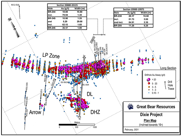
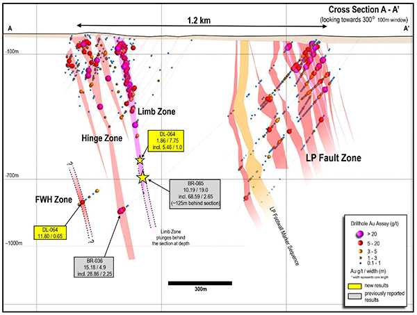
New LP Fault drill results from this release are provided in Table 1, Figure 1, Figure 3, Figure 4 and Figure 5. Table 2 contains drill results from other targets. A new 1.2 kilometre cross section showing all gold zones as drilled to date is provided in Figure 2.
New LP Fault Drill Results
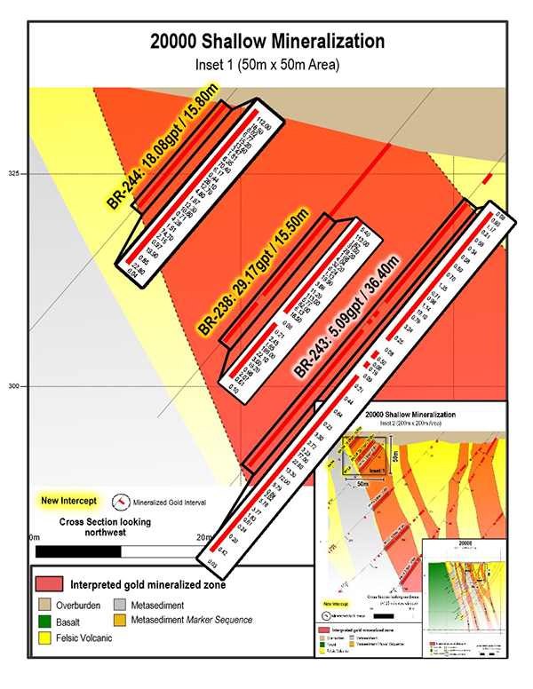
- 29.17 g/t gold over 15.50 metres from 41.80 to 57.30 metres in drill hole BR-238 on drill section 19975.
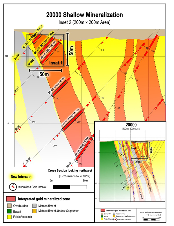
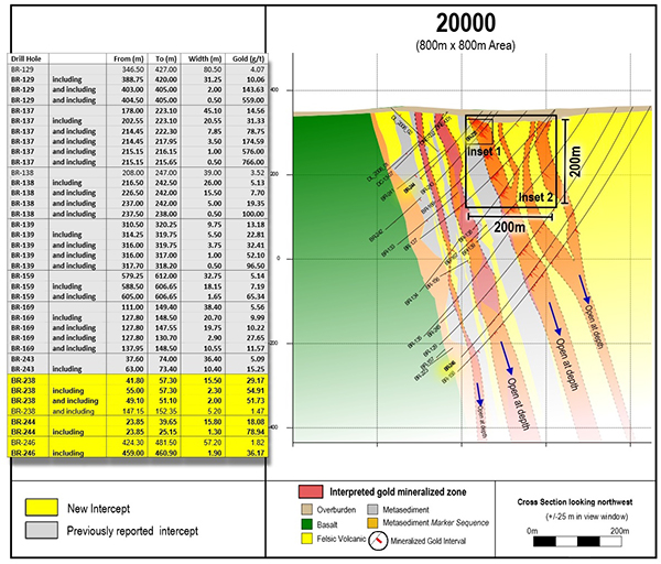
- 18.08 g/t gold over 15.80 metres from 23.85 (bedrock surface) to 39.65 metres in drill hole BR-244 on drill section 20000, located 25 metres northwest of drill section 19975.
- Detailed assay results are provided on drill section 20000 at three different scales (50 x 50 metre, 200 x 200 metre, and 800 x 800 metre) in Figures 3, 4 and 5.
- Drill hole BR-255 on drill section 19900, located 75 metres to the southeast of drill section 19975 included multiple gold intervals:
- 4.09 g/t gold over 30.40 metres from 22.10 (bedrock surface) to 52.50 metres, and
- 4.35 g/t gold over 15.75 metres from 63.00 to 78.75 metres. This included a high-grade core of 11.25 g/t gold over 5.25 metres from 73.50 to 78.75 metres.
- Deeper drill hole BR-245 intersected 5.29 g/t gold over 29.00 metres from 397.50 to 426.50 metres on drill section 20050, which included a high-grade core of 62.13 g/t gold over 1.60 metres from 405.00 to 406.60 metres.
- Deeper drill hole BR-246 intersected 1.82 g/t gold over 57.20 metres from 424.30 to 481.50 metres on drill section 20000. This included a high-grade core of 36.17 g/t gold over 1.90 metres from 333.90 to 340.85 metres.
- Strong continuity of gold mineralization continues to be observed on a section-by-section basis, and vertically within drill sections.
Figure 1: Map of current drill results showing the location of the new 1.2 kilometre cross section.
Figure 2: Updated 1.2 kilometre cross section showing multiple sub-parallel gold zones as drilled to date at Dixie, based on approx. 460 drill holes reported by Great Bear (located on Figure 1). The new high-grade vein zone (FWH) discovery beside the Hinge zone is shown.
Figure 3: Near-surface gold results on drill section 20000. All individual assays are shown. 50 x 50 m view.
Figure 4: Shallow gold results from drill section 20000. 200 x 200 m view.
Figure 5: Complete drill section 20000 as drilled to date, showing insets of previous figures and highlights of past and current drilling. 800 x 800 m view.
Other Drill Results
Preparation for Dixie Limb and Hinge Zone Directional Drilling
- The Company is planning to complete systematic directed grid drilling of the Dixie Limb and Hinge zones to depths of up to 800 metres as part of its current maiden resource definition drill program, details of which will be provided over the coming weeks. No mineral resource estimate has been completed in accordance with NI 43-101 at this time.
- An existing drill hole, DL-064 was extended to cross the Dixie Limb and Hinge zones at a location where it will be used as a pilot hole for wedge (directed) drilling designed to define mineralization at vertical depths of 500 – 800 metres.
- While DL-064 did not target high-grade gold mineralization, it successfully intersected both the Dixie Limb and Hinge zones where predicted by Great Bear’s models, returning moderate gold grades of 1.86 g/t gold over 7.75 metres including 5.46 g/t gold over 1.0 metre as shown in Table 2. Results confirm the Company’s models continue to correctly predict mineralization to within a few metres of expected locations.
- Follow up drilling will include targeting of high-grade mineralization around the deep Dixie Limb (10.19 g/t gold over 19.00 metres; May 11, 2020) and Hinge (15.18 g/t gold over 4.90 metres; December 9, 2020) zones using the DL-064 pilot hole and other planned drill holes.
- DL-064 was allowed to continue at depth and intersected a new Hinge style vein zone to the southwest of the Hinge zone, returning 11.80 g/t gold over 0.65 metres near the bottom of the hole from 1166.00 to 1166.65 metres down hole. Follow-up drilling is required, as the new zone is interpreted as an entirely new high-grade vein occurrence.
Metallurgical Drilling
- Two larger diameter (HQ) drill holes were completed into the LP Fault to provide material for metallurgical testing at various gold grades, and to test if drill core size has any impact on reported gold assay grades.
- Drill hole BRH-001 intersected 2.33 g/t gold over 15.25 metres from 77.75 to 93.00 metres on drill section 20075.
- Drill hole BRH-002 intersected 6.71 g/t gold over 3.85 metres from 59.25 to 63.10 metres and 0.79 g/t gold over 43.55 metres from 154.00 to 197.55 metres on drill section 20075.
- A series of follow-up metallic screen, gravimetric and other fire assay gold recovery tests, along with 41 element ICP work were conducted on these samples, while geology and alteration were characterized in detail. Results will be compared to standard diameter (NQ) drill results from the LP Fault zone.
- Metallurgical sample selection and testing of high, medium and low-grade LP Fault samples is ongoing. Results will be reported as they become available and are not expected to differ significantly from gold recoveries reported for the Hinge and Dixie Limb zones (see news releases of January 25, 2021 and September 22, 2020).
Regional Drilling
- The Company is undertaking a limited program of ongoing regional exploration, accounting for less than 5% of total metres drilled. Ten widely spaced regional reconnaissance drill holes (REG-003 to 010) were completed 500 metres to 2.0 kilometres to the northwest of the Dixie Limb and Hinge zones, along the axis of a regional D2 fold. These holes were designed to test for gold mineralization and develop a better understanding of the regional geology.
- New gold-bearing quartz veins were encountered in 9 of 10 drill holes, returning gold values between 0.26 and 0.64 g/t gold over widths of 0.50 to 6.15 metres. The best intercept was located approximately 200 metres to the northwest of, and at shallower depths than, the Arrow zone discovery (see news release of June 18, 2020), assaying 8.29 g/t gold over 1.00 metre from 251.00 to 252.00 metres in drill hole REG-011. See Table 2.
- The gold-bearing veins in REG-011 are visually identical to the Arrow zone discovery and may comprise the up-dip, along strike extension of the zone. More drilling is required.
- Gold mineralization has now been confirmed along more than 2.0 kilometres of strike length of the D2 fold axis.
- Drill targets in this area consist mainly of mafic volcanic hosted, steeply-plunging gold-bearing veins similar to most gold occurrences in the Red Lake district, and differing in mineralization style and host rock type from the LP Fault.
- More drilling will be undertaken in future after completion of currently planned grid drill programs at the LP Fault, Dixie Limb and Hinge zone.
Table 1: New assay results from the LP Fault, arranged by drill section from southeast to northwest. Note BRH-001 and 002 are larger core diameter metallurgical test holes.
| Drill Hole | From (m) | To (m) | Width* (m) | Gold (g/t) | Section | |
| BR-254 | 25.50 | 30.45 | 4.95 | 4.95 | 19900 | |
| BR-255 | 22.10 | 52.50 | 30.40 | 4.09 | 19900 | |
| and | 63.00 | 78.75 | 15.75 | 4.35 | ||
| including | 73.50 | 78.75 | 5.25 | 11.25 | ||
| and | 271.05 | 274.35 | 3.30 | 4.84 | ||
| BR-238 | 41.80 | 57.30 | 15.50 | 29.17 | 19975 | |
| including | 55.00 | 57.30 | 2.30 | 54.91 | ||
| and including | 49.10 | 51.10 | 2.00 | 51.73 | ||
| and | 147.15 | 152.35 | 5.20 | 1.47 | ||
| BR-244 | 23.85 | 39.65 | 15.80 | 18.08 | 20000 | |
| including | 23.85 | 25.15 | 1.30 | 78.94 | ||
| BR-246 | 424.30 | 481.50 | 57.20 | 1.82 | 20000 | |
| 459.00 | 460.90 | 1.90 | 36.17 | |||
| BR-245 | 333.90 | 340.85 | 6.95 | 2.19 | 20050 | |
| including | 338.75 | 339.95 | 1.20 | 10.90 | ||
| and | 397.50 | 426.50 | 29.00 | 5.29 | ||
| including | 405.00 | 406.60 | 1.60 | 62.13 | ||
| BRH-001 | 77.75 | 93.00 | 15.25 | 2.33 | 20075 | |
| BRH-002 | 59.25 | 63.10 | 3.85 | 6.71 | 20075 | |
| and | 154.00 | 197.55 | 43.55 | 0.79 | ||
| BR-228 | 373.40 | 422.30 | 48.90 | 0.78 | 20125 | |
| BR-229 | 455.00 | 480.50 | 25.50 | 1.05 | 20125 |
* Widths are drill indicated core length, as insufficient drilling has been undertaken to determine true widths at this time. Average grades are calculated with un-capped gold assays, as insufficient drilling has been completed to determine capping levels for higher grade gold intercepts. Interval widths are calculated using a 0.10 g/t gold cut-off grade with up to 3 m of internal dilution of zero grade.
Table 2: Other drill results organized by area.
| Drill Hole | From (m) | To (m) | Width* (m) | Gold (g/t) | Area | |
| DL-063A** | 144.50 | 145.50 | 1.00 | 3.50 | ||
| DL-064 | 798.65 | 806.40 | 7.75 | 1.86 | Dixie Limb | |
| including | 803.55 | 804.55 | 1.00 | 5.46 | Dixie Limb | |
| and | 1076.25 | 1082.45 | 6.20 | 1.35 | Hinge | |
| including | 1076.25 | 1077.35 | 1.10 | 4.28 | Hinge | |
| and | 1164.60 | 1166.65 | 2.05 | 4.41 | DHZ-FWH | |
| including | 1166.00 | 1166.65 | 0.65 | 11.80 | DHZ-FWH | |
| REG-003 | 390.40 | 394.00 | 3.60 | 0.35 | Regional | |
| REG-004 | 630.00 | 631.50 | 1.50 | 0.26 | Regional | |
| and | 688.00 | 689.50 | 1.50 | 0.64 | ||
| REG-005 | 96.50 | 97.35 | 0.85 | 0.64 | Regional | |
| and | 274.50 | 275.00 | 0.50 | 0.57 | ||
| REG-006 | 352.75 | 353.75 | 1.00 | 0.43 | Regional | |
| REG-007 | 266.45 | 267.00 | 0.55 | 0.32 | Regional | |
| REG-008 | 240.00 | 241.50 | 1.50 | 0.54 | Regional | |
| REG-009 | 76.90 | 83.05 | 6.15 | 0.27 | Regional | |
| and | 562.20 | 563.20 | 1.00 | 0.60 | ||
| REG-010 | No significant values | Regional | ||||
| REG-011 | 115.50 | 117.00 | 1.50 | 0.55 | Arrow | |
| and | 251.00 | 252.00 | 1.00 | 8.29 | ||
| and | 279.00 | 281.00 | 2.00 | 0.78 | ||
* Widths are drill indicated core length, as insufficient drilling has been undertaken to determine true widths at this time. Average grades are calculated with un-capped gold assays, as insufficient drilling has been completed to determine capping levels for higher grade gold intercepts. Interval widths are calculated using a 0.10 g/t gold cut-off grade with up to 3 m of internal dilution of zero grade. ** Hole was abandoned before reaching target depth due to excessive deviation.
Great Bear’s progress can be followed using the Company’s plan maps, long sections and cross sections, and through the VRIFY model posted at the Company’s web site at www.greatbearresources.ca, which will next be updated in Q2 2021. All LP Fault drill hole highlighted assays, plus drill collar locations and orientations can also be downloaded at the Company’s web site.
Drill collar location, azimuth and dip for drill holes included in this release are provided in the table below (UTM zone 15N, NAD 83):
| Hole ID | Easting | Northing | Elevation | Length | Dip | Azimuth |
| BR-228 | 457512 | 5634241 | 366 | 745 | -60 | 207 |
| BR-229 | 457556 | 5634298 | 368 | 633 | -58 | 209 |
| BR-238 | 457506 | 5633874 | 350 | 276 | -51 | 194 |
| BR-244 | 457487 | 5633860 | 351 | 318 | -49 | 206 |
| BR-245 | 457596 | 5634180 | 363 | 675 | -58 | 211 |
| BR-246 | 457651 | 5634177 | 361 | 723 | -63 | 208 |
| BR-254 | 457574 | 5633821 | 353 | 237 | -52 | 204 |
| BR-255 | 457585 | 5633855 | 354 | 339 | -63 | 202 |
| BRH-001 | 457435 | 5633944 | 352 | 147 | -55 | 204 |
| BRH-002 | 457467 | 5634028 | 353 | 249 | -48 | 201 |
| DL-063A | 456723 | 5633985 | 362 | 741 | -60 | 225 |
| DL-064 | 456790 | 5633950 | 359 | 1188 | -54 | 222 |
| REG-003 | 456059 | 5634396 | 369 | 561 | -55 | 220 |
| REG-004 | 456214 | 5634182 | 376 | 714 | -50 | 240 |
| REG-005 | 455339 | 5634318 | 373 | 540 | -55 | 218 |
| REG-006 | 455145 | 5633967 | 361 | 556 | -55 | 217 |
| REG-007 | 454953 | 5633693 | 359 | 516 | -55 | 214 |
| REG-008 | 455602 | 5633733 | 364 | 493 | -60 | 219 |
| REG-009 | 455737 | 5634007 | 363 | 699 | -56 | 209 |
| REG-010 | 456380 | 5636480 | 407 | 510 | -55 | 204 |
| REG-011 | 455601 | 5633940 | 363 | 468 | -60 | 220 |
About the Dixie Project
The Dixie Project is 100% owned, comprised of 9,140 hectares of contiguous claims that extend over 22 kilometres, and is located approximately 25 kilometres southeast of the town of Red Lake, Ontario. The project is accessible year-round via a 15 minute drive on a paved highway which runs the length of the northern claim boundary and a network of well-maintained logging roads.
The Dixie Project hosts two principal styles of gold mineralization:
- High-grade gold in quartz veins and silica-sulphide replacement zones (Dixie Limb, Hinge and Arrow zones). Hosted by mafic volcanic rocks and localized near regional-scale D2 fold axes. These mineralization styles are also typical of the significant mined deposits of the Red Lake district.
- High-grade disseminated gold with broad moderate to lower grade envelopes (LP Fault). The LP Fault is a significant gold-hosting structure which has been seismically imaged to extend to 14 kilometres depth (Zeng and Calvert, 2006), and has been interpreted by Great Bear to have up to 18 kilometres of strike length on the Dixie property. High-grade gold mineralization is controlled by structural and geological contacts, and moderate to lower-grade disseminated gold surrounds and flanks the high-grade intervals. The dominant gold-hosting stratigraphy consists of felsic sediments and volcanic units.
About Great Bear
Great Bear Resources Ltd. is a well-financed gold exploration company managed by a team with a track record of success in mineral exploration. Great Bear is focused on the prolific Red Lake gold district in northwest Ontario, where the company controls over 330 km2 of highly prospective tenure across 5 projects: the flagship Dixie Project (100% owned), the Pakwash Property (earning a 100% interest), the Dedee Property (earning a 100% interest), the Sobel Property (earning a 100% interest), and the Red Lake North Property (earning a 100% interest) all of which are accessible year-round through existing roads.
QA/QC and Core Sampling Protocols
Drill core is logged and sampled in a secure core storage facility located in Red Lake Ontario. Core samples from the program are cut in half, using a diamond cutting saw, and are sent to Activation Laboratories in Ontario, an accredited mineral analysis laboratory, for analysis. All samples are analysed for gold using standard Fire Assay-AA techniques. Samples returning over 10.0 g/t gold are analysed utilizing standard Fire Assay-Gravimetric methods. Pulps from approximately 5% of the gold mineralized samples are submitted for check analysis to a second lab. Selected samples are also chosen for duplicate assay from the coarse reject of the original sample. Selected samples with visible gold are also analyzed with a standard 1 kg metallic screen fire assay. Certified gold reference standards, blanks and field duplicates are routinely inserted into the sample stream, as part of Great Bear’s quality control/quality assurance program (QAQC). No QAQC issues were noted with the results reported herein.
Qualified Person and NI 43-101 Disclosure
Mr. R. Bob Singh, P.Geo, VP Exploration, and Ms. Andrea Diakow P.Geo, Exploration Manager for Great Bear are the Qualified Persons as defined by National Instrument 43-101 responsible for the accuracy of technical information contained in this news release.
ON BEHALF OF THE BOARD
“Chris Taylor”
Chris Taylor, President and CEO
Investor Inquiries:
Mr. Knox Henderson
Tel: 604-646-8354
Direct: 604-551-2360
info@greatbearresources.ca
www.greatbearresources.ca
Cautionary note regarding forward-looking statements
This release contains certain “forward looking statements” and certain “forward-looking information” as defined under applicable Canadian and U.S. securities laws. Forward-looking statements and information can generally be identified by the use of forward-looking terminology such as “may”, “will”, “should”, “expect”, “intend”, “estimate”, “anticipate”, “believe”, “continue”, “plans” or similar terminology. The forward-looking information contained herein is provided for the purpose of assisting readers in understanding management’s current expectations and plans relating to the future. Readers are cautioned that such information may not be appropriate for other purposes.
Forward-looking statements and information include, but are not limited to, statements in respect of the proposed Offering including the proposed use of proceeds, the closing date of the Offering, receipt of regulatory and stock exchange approvals, the timing of future drilling, exploration and budgets.
Forward-looking information are based on management of the parties’ reasonable assumptions, estimates, expectations, analyses and opinions, which are based on such management’s experience and perception of trends, current conditions and expected developments, and other factors that management believes are relevant and reasonable in the circumstances, but which may prove to be incorrect.
Such factors, among other things, include: impacts arising from the global disruption caused by the Covid-19 coronavirus outbreak, business integration risks; fluctuations in general macroeconomic conditions; fluctuations in securities markets; fluctuations in spot and forward prices of gold or certain other commodities; change in national and local government, legislation, taxation, controls, regulations and political or economic developments; risks and hazards associated with the business of mineral exploration, development and mining (including environmental hazards, industrial accidents, unusual or unexpected formations pressures, cave-ins and flooding); discrepancies between actual and estimated metallurgical recoveries; inability to obtain adequate insurance to cover risks and hazards; the presence of laws and regulations that may impose restrictions on mining; employee relations; relationships with and claims by local communities and indigenous populations; availability of increasing costs associated with mining inputs and labour; the speculative nature of mineral exploration and development (including the risks of obtaining necessary licenses, permits and approvals from government authorities); and title to properties.
Great Bear undertakes no obligation to update forward-looking information except as required by applicable law. Such forward-looking information represents management's best judgment based on information currently available. No forward-looking statement can be guaranteed and actual future results may vary materially. Accordingly, readers are advised not to place undue reliance on forward-looking statements or information.


