Fireweed Zinc Announces New Targets & 2019 Exploration Plans
Vancouver, British Columbia: FIREWEED ZINC LTD. (“Fireweed” or the “Company”) (TSXV: FWZ) is pleased to announce plans for its 2019 exploration program on the Macmillan Pass Zinc Project in Yukon, Canada. The Company anticipates that the drilling campaign will start in June and will include both greenfield targets and step-out drill targets.
Highlights
- 2019 plans for at least 2000 m core drilling and 1000 m of RC drilling
- Drilling of prospective greenfield targets to test for new deposits on the 544 km2 property, with emphasis on the Fertile Corridor
- Drilling of step-out drill targets with strong upside potential at Tom North, Tom East, Jason North and End Zone
- Continued field exploration including geophysical, geochemical and geological mapping surveys
CEO Statement
Fireweed CEO Brandon Macdonald stated “I am very excited about our 2019 exploration plans as we continue to build the Macmillan Pass Project through both expansion of one of the largest undeveloped zinc resources in the world and exploration for new discoveries on our under-explored district-scale property.
“Our 2018 work program generated many exceptional greenfield targets. New prospective geophysical and geochemical anomalies have been outlined along part of the Fertile Corridor, a trend already known to host large mineralized systems including the Tom and Jason deposits, as well as the End Zone and Boundary Zone. We believe there is strong potential for discovery of another large zinc deposit in the district and have designed our 2019 exploration program using state-of-the-art technologies successfully tested in 2018 to locate it while at the same time carrying out step-out drilling to expand the large known resources.”
2019 Drill Program
A number of compelling drill targets have been generated based on Fireweed’s 2017 and 2018 exploration results and re-interpretation of historic data. The 2019 drill program will test the highest priority targets: those where exploration success is deemed most likely to result in either the greenfield discovery of a new zinc-lead-silver deposit, or in the expansion of known zones that could have a significant impact on project economics. To test as many targets as possible at the lowest cost, Fireweed will employ an innovative small reverse circulation (RC) drill with a minimal environmental impact to rapidly test targets with a series of short holes recovering samples from overburden and short bedrock intervals. RC samples will be analysed in the field for zinc, lead, silver and other elements with a portable XRF analyser allowing for immediate follow up of results. The RC drill results will then be used to rank targets for testing with the larger conventional core drill. The core drill will also be employed for step-out holes on known zones of mineralization. The targets planned for drill testing in 2019 are described below.
2019 Greenfield Drill Targets
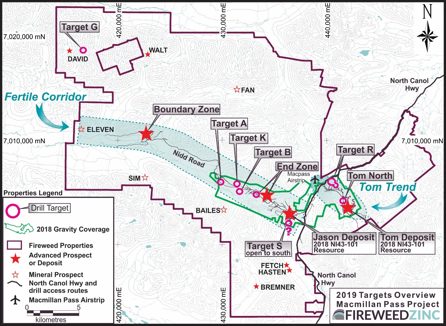
The 2019 greenfield targets have potential for significant new discoveries (Map 1). These are new targets generated by Fireweed over the past two years. Most are in areas where bedrock is concealed by overburden and have never been drilled. Many of the targets are located along the Fertile Corridor, a belt of critical host geology that straddles a major synsedimentary structure, the Hess Fault Zone, and is deemed highly prospective for shale-hosted zinc-lead-silver mineralization. Four large zinc systems are located within the Fertile Corridor, including the Tom and Jason deposits.
Priority targets are described below. Other greenfield targets identified on the property will be further evaluated in the field this summer with the objective of developing additional drill targets.
Target A and Target B
These newly defined, strong coincident gravity-magnetic high anomalies west of End Zone are located within the Fertile Corridor (Map 2). The anomaly at Target B is also marked by conventional B/C horizon lead-in-soil anomalies1. RC drilling is initially planned to test these anomalies.
Target G
A 2.5 kilometer long lead-in-soil anomaly1 (the David Anomaly) has been outlined in the northern part of the property (see Map 1) through compilation of historic data and field investigations by Fireweed crews in 2018. The area is deemed highly prospective, as it is located adjacent to a major fault structure, the MacMillan Fault, and hosts abundant bedded barite showings which can act as a trap for zinc-lead-silver bearing fluids.
In 2018, in the eastern part of the David Anomaly at Target G, Fireweed crews discovered coarse zinc-lead-silver mineralization hosted in barite. A grab sample from loose surface rocks assayed 14.39% lead, 4.42% zinc and 312 g/t silver.
Plans for 2019 include a surface mapping and sampling program over the length of the large anomaly followed by drilling of the most prospective sections.
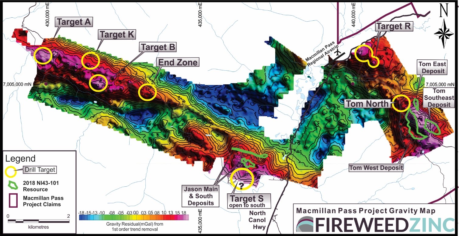
Multiple new drill targets defined in overburden covered areas
Target K
A moderate SGH2 soil anomaly (Map 3) was detected west of End Zone on the Fertile Corridor trend. RC drilling is initially planned to test this anomaly.
Target R
Coincident strong gravity-magnetic highs and a moderate SGH2 soil anomaly (Maps 2,3) were detected north of the Tom deposits near the access road. An initial core drill hole is planned to test this anomaly.
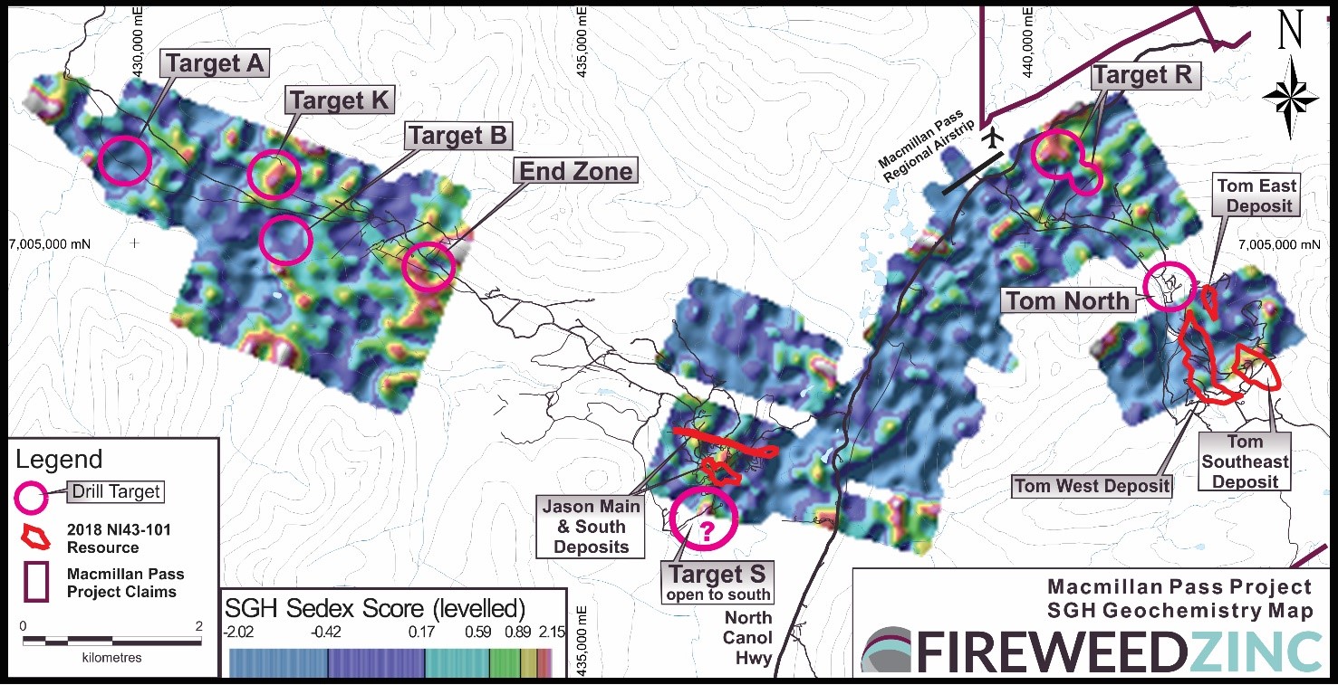
New drill targets defined with deep geochemistry
Target S
A large, strong gravity anomaly has been detected south of the Jason deposits (Map 2). This anomaly was partially defined in 2018 and will be fully outlined early in the 2019 field season with additional gravity surveying to better target 2019 drill holes.
2019 Step-Out Drill Targets
Interpretation of drill data from 2017 and 2018, in addition to the re-interpretation of historic data, has led to the generation of new targets that represent either potential extensions to known, high-grade zones, or highlight potential new zones that may occur near surface in the vicinity of the Tom and Jason deposits.
Tom North Drill Target
Interpretation of historic drilling and trenching results immediately north of the Tom West deposit has led to the delineation of a new step-out drill target with large upside potential: Tom North. Six shallow holes drilled at Tom North in 1951-52 plus one additional hole in 1978 returned assays up to 5.05% zinc and 1.80% lead over 19.9 m (see other drill results on Map 4)3. Fireweed drilling elsewhere at Tom demonstrated that many early historic drill results under-reported grades due to poor core recoveries (see examples in 2017 and 2018 Fireweed drilling news releases). Mapping and 2018 exploration data suggest that Tom North may be an extension of Tom West separated by a fault.
The Tom North target has been traced in sparse historic drill holes and trenches over a strike length of 600 m and only to shallow depths of about 50 m. Fireweed plans to drill the continuation of Tom North to depth to test its potential for mineralization amenable to open-pit mining and to test for thicker mineralization that is similar to the adjacent Tom West Zone1.
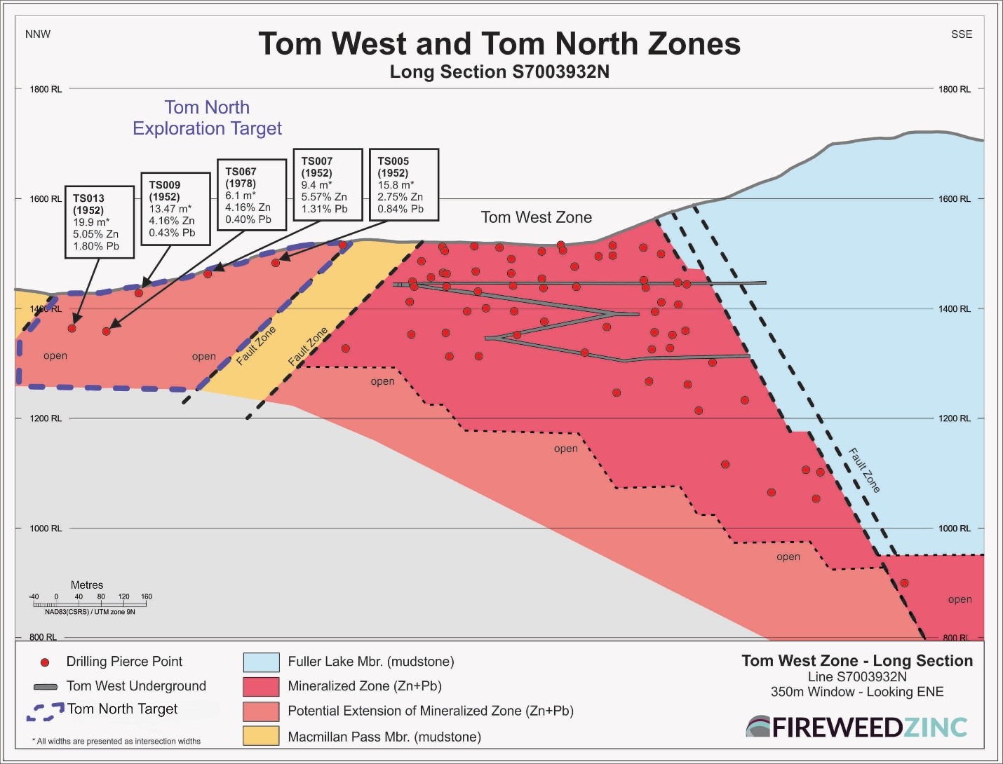
A new drill target found in old data
Tom East Expansion Target
Tom East is one of the highest grade zones on the property. In 2018, drilling extended the zone to depth with the deepest hole intersecting 16.4 m grading 21.14% zinc, 13.55% lead and 243 g/t silver (Figure 5; see Fireweed news release dated September 20, 2018 for details). The zone remains open for expansion with plans to continue testing its depth extension by core drilling in 2019.
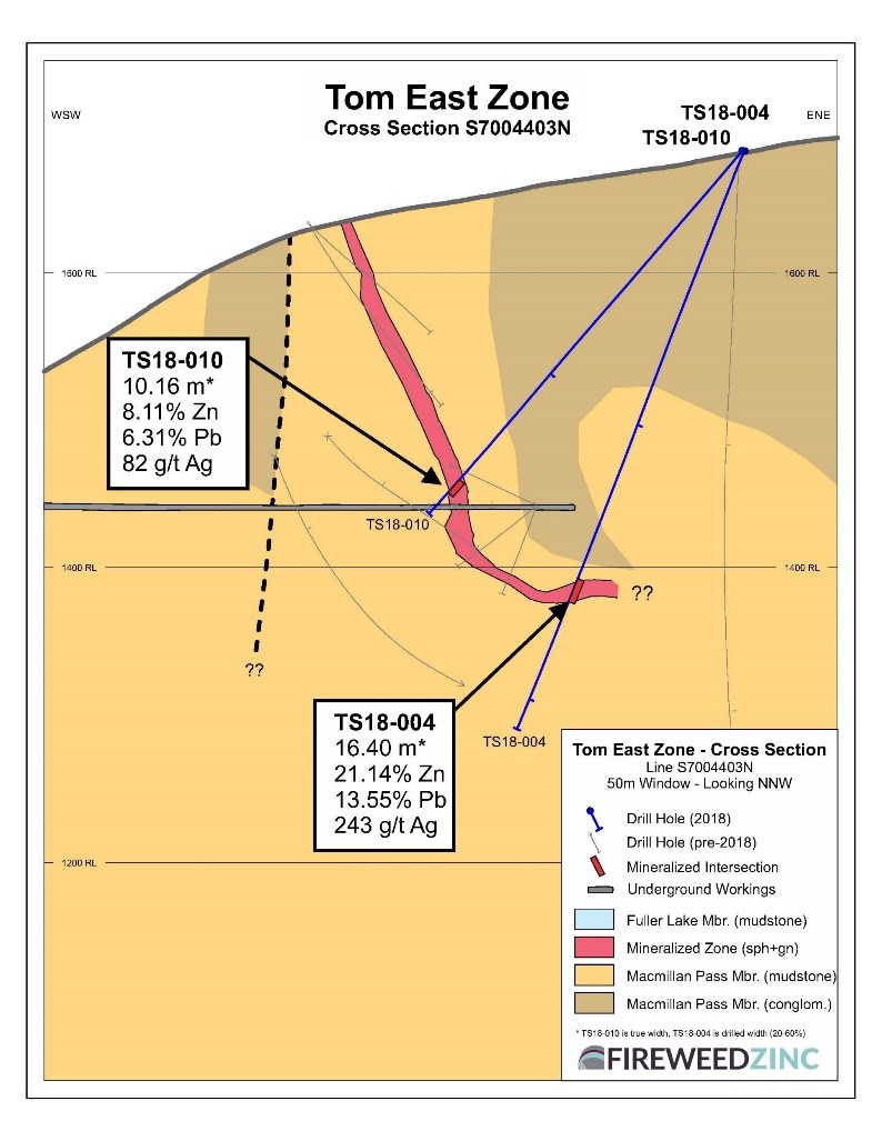
2019 step-out drilling planned to expand on 2018 high grade drill results
Jason North Target
Jason North is a new untested drill target located immediately north of the Jason Main Deposit. It was defined through re-interpretation of historic data, and confirmed by soil sampling in 2018. The Jason Main and Jason South Zones are interpreted to be the same zone connected by a syncline fold at depth (Figure 6). A second zone with high grade historic drill intersections, Lower Jason South, occurs 20-30 m below the Jason South Zone and may similarly project around the syncline fold to a location north of Jason Main (Jason North). The Jason North area is marked by a strong lead-in-soil anomaly1, a strong basal overburden historic RC drill lead-in-soil anomaly, and a strong, double-peaked geophysical electromagnetic conductor consistent with a steeply-dipping conductive mineralized body. Despite its location close to the Jason Main Deposit, Jason North has never been drilled.
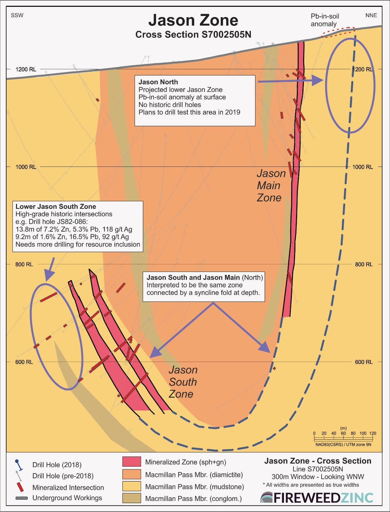
A new drill target found in old data
Boundary Zone and End Zone Targets
Fireweed is currently evaluating data from two other large known zones of mineralization at End Zone and Boundary Zone (Map 1). These zones contain significant zinc-lead-silver mineralization that has been drilled but not yet classified as mineral resources. Pending the results of these studies, Fireweed may drill additional holes to evaluate and test extensions of these zones.
2019 Field Exploration Plans
Test gravity surveys in 2018 showed prominent anomalies over the Tom and Jason deposits, and demonstrated that properly controlled and corrected ground gravity surveys are an effective tool to detect zinc mineralization on the property. These successful tests were followed by expanded gravity surveys which detected several prominent new gravity anomaly targets that will be drill tested for mineralization in 2019 as described above. Geophysical plans for 2019 include extending gravity surveying west along the Fertile Corridor, completion of the gravity grid in the Target S area south of Jason and additional gravity surveying in the Tom deposits area. An airborne LiDAR topographic survey of the entire property will be completed in 2019 to improve corrections applied to gravity data for exploration and new target definition as well as aid engineering and environmental studies.
Continued soil geochemical surveys are planned for select areas of the property and extensive geological mapping will be carried out this summer to advance Fireweed’s understanding of the geological controls on mineralization and further delineate highly prospective areas.
Technical information in this news release has been reviewed and approved by Gilles Dessureau, P.Geo, Vice President, Exploration and a ‘Qualified Person’ as defined under Canadian National Instrument 43?101.
Amendment to Golden Ridge Option Agreement
The Company has signed an amendment to the option agreement with Golden Ridge for the NS and BR claims at Macmillan Pass. The amendment reduces the cash payment and increases the number of shares for the option payment due in May 2019. The number of shares issued changes from 75,000 to 121,875, while the cash payment to Golden Ridge is reduced from $75,000 to $37,500. In all other respects, the option agreement remains unchanged. This amendment is subject to TSX Venture Exchange approval.
About Fireweed Zinc Ltd. (TSXV: FWZ): Fireweed Zinc is a public mineral exploration company focused on zinc and managed by a veteran team of mining industry professionals. The Company is advancing its district-scale 544 km2 Macmillan Pass Project in Yukon, Canada, which is host to the 100% owned Tom and Jason zinc-lead-silver deposits with current Mineral Resources and a PEA economic study (see Fireweed news releases dated January 10, 2018, and May 23, 2018, respectively, and reports filed on www.sedar.com for details) as well as the Boundary Zone and End Zone which have significant zinc-lead-silver mineralization drilled but not yet classified as mineral resources. The project also includes option agreements on large blocks of adjacent claims (MAC, MC, MP, Jerry, BR and NS) which cover exploration targets in the district where previous and recent work identified zinc, lead and silver prospects, and geophysical and geochemical anomalies in prospective host geology.
Additional information about Fireweed Zinc and its Macmillan Pass Zinc Project can be found on the Company’s website at www.FireweedZinc.com and at www.sedar.com.
ON BEHALF OF FIREWEED ZINC LTD.
“Brandon Macdonald”
CEO & Director
Neither the TSX Venture Exchange nor its Regulation Services Provider (as that term is defined in the policies of the TSX Venture Exchange) accepts responsibility for the adequacy or accuracy of this release.
Cautionary Statements
This news release may contain “forward-looking” statements and information relating to the Company and the Macmillan Pass Project that are based on the beliefs of Company management, as well as assumptions made by and information currently available to Company management. Such statements reflect the current risks, uncertainties and assumptions related to certain factors including but not limited to, without limitations, exploration and development risks, expenditure and financing requirements, general economic conditions, changes in financial markets, the ability to properly and efficiently staff the Company’s operations, the sufficiency of working capital and funding for continued operations, title matters, First Nations relations, operating hazards, political and economic factors, competitive factors, metal prices, relationships with vendors and strategic partners, governmental regulations and oversight, permitting, seasonality and weather, technological change, industry practices, and one-time events. Additional risks are set out in the Company’s prospectus dated May 9, 2017, and filed under the Company’s profile on SEDAR at www.sedar.com. Should any one or more risks or uncertainties materialize or change, or should any underlying assumptions prove incorrect, actual results and forward-looking statements may vary materially from those described herein. The Company does not undertake to update forward?looking statements or forward?looking information, except as required by law.
Notes on Sampling and Analyses
The 2018 geochemical sampling programs were carried out using industry best practices. Conventional B- and C-horizon soil samples were collected on 200 m by 50 m grid lines. Samples were collected with a shovel, placed in kraft paper bags and dried in camp. Samples were sent to the Bureau Veritas preparation laboratory in Whitehorse, Yukon where the samples were further dried and sieved to recover the -230 mesh (sub 63 micron) fraction pulp for analysis. Pulps were then shipped to the Bureau Veritas laboratory in Vancouver for modified aqua regia digestion (1:1:1 HNO3:HCl:H2O) followed by 37 element Inductively Coupled Plasma Mass Spectrometry (“ICP-MS”) analyses which included zinc, lead and silver results. Bureau Veritas (Vancouver) is an independent, international ISO/IEC 17025:2005 accredited laboratory.
SGH (spatiotemporal geochemical hydrocarbon) soil sampling is a new geochemical technology used at Macmillan Pass in 2018 for the first time. SGH soil samples were collected on 200 m by 50 m grid lines mainly along the Fertile Corridor. Samples were collected with a shovel, placed in plastic ziplock bags and stored in camp. Samples were sent to Activation Laboratories (“Actlabs”) in Ancaster, Ontario, where they were processed using Actlabs proprietary SGH technology and interpreted for “SEDEX” type massive sulphide deposits to generate SEDEX Score values. Actlabs states that the designated hydrocarbons detected are from the decomposition of bacteria that use the target mineralization as a food source and provide forensic identification of the mineralization at depth. Actlabs (Ancaster) is an independent, international ISO/IEC 17025:2005 accredited laboratory.
Rock samples were collected in the course of 2017 and 2018 field work as needed. Samples are sent to the Bureau Veritas (formerly Acme Labs) preparation laboratory in Whitehorse, Yukon where the samples were crushed and pulverized to 85% passing 200 mesh size pulps. A 250-gram split of each pulp was then sent to the Bureau Veritas laboratory in Vancouver, B.C. and analyzed by 1:1:1 Aqua Regia digestion followed by Inductively Coupled Plasma Mass Spectrometry (ICP-ES/ICP-MS) multi-element analyses (BV Code AQ270). All samples were also analyzed by lithium borate fusion and X-ray fluorescence analysis (XRF) finish (BV Code LF725). Over-limit Pb (>25.0%) and Zn (>24.0%) were analyzed by lithium borate fusion with XRF finish (BV Code LF726). Bureau Veritas (Vancouver) is an independent, international ISO/IEC 17025:2005 accredited laboratory.
A rigorous Quality Assurance\Quality Control program was implemented for the soil and rock sampling programs. Field duplicates and certified reference materials were inserted in the sample stream at the rate of 1 in 20 samples. Internal laboratory duplicates were analyzed to ensure that precision fell within acceptable levels for exploration data.
Footnotes:
- Exploration using soil geochemistry in the Macmillan Pass area focuses more on lead-in-soil anomalies rather than zinc-in-soil anomalies because zinc is more mobile in the surface soils and as such its occurrence is widespread and not necessarily indicative of nearby mineralization, whereas lead is less mobile and is more typically detected in elevated amounts closer to bedrock mineralization
- Spatiotemporal geochemical hydrocarbon (SGH) soil sampling is a new geochemical method described in the Note on Sampling and Analysis section above. SGH SEDEX score values re-interpreted by Fireweed are shown on Map 3.

